Log in
All resources
Create a design
451 Free Artworks of Maps Of North America
bibliothèque nationale de france
island of california
sanson maps of north america
maps in the library of congress
lawrence h. slaughter collection of english maps, charts, globes, books and atlases
maps by richard william seale
richard william seale
a map of the british empire in america with the french and spanish settlements adjacent thereto
maps by nicolas sanson
1669 maps of north america
maps of america by guillaume delisle (18th century)
1760s maps of the americas
robert wallis (engraver)
henry warren
maps of the indigenous peoples of north america
renaissance
sanson maps of north america
maps by nicolas sanson
sanson maps of north america
maps by nicolas sanson
maps by emanuel bowen
robert sayer
sanson maps of north america
maps by nicolas sanson
sanson maps of north america
maps by nicolas sanson
sanson maps of north america
maps by nicolas sanson
maps by willem and johannes blaeu
1660s maps of the americas
lawrence h. slaughter collection of english maps, charts, globes, books and atlases
nypl lionel pincus and princess firyal map division
lawrence h. slaughter collection of english maps, charts, globes, books and atlases
nypl lionel pincus and princess firyal map division
old maps of north america from the norman b. leventhal map center
1740 maps of north america
1690s maps of the caribbean
1690s maps of the americas
maps in the library of congress
1763 maps of north america
maps by jacques-nicolas bellin
old maps of new france
sanson maps of north america
island of california
1677 maps of north america
island of california
sanson maps of north america
maps by nicolas sanson
sanson maps of north america
island of california
sanson maps of north america
island of california
sanson maps of north america
1690s maps of north america
lawrence h. slaughter collection of english maps, charts, globes, books and atlases
nypl lionel pincus and princess firyal map division
maps in the library of congress
1768 maps of north america
sanson maps of north america
island of california
sanson maps of north america
island of california
sanson maps of north america
island of california
sanson maps of north america
island of california
sanson maps of north america
island of california
sanson maps of north america
1674 maps of north america
1849 maps of north america
old maps of canada
1600s maps of north america
1600s maps of south america
william henry toms
henry popple
sanson maps of north america
1719 maps of north america
maps of north america, nypl collection
novi belgii, atlas maior
a map of the british empire in america with the french and spanish settlements adjacent thereto
1730s maps of the caribbean
sanson maps of north america
island of california
considérations géographiques et physiques sur les nouvelles découvertes au nord de la grande mer
1755 maps of north america
maps by thomas kitchin
1764 maps of quebec
lawrence h. slaughter collection of english maps, charts, globes, books and atlases
covens en mortier
maps in the library of congress
1771 maps of north america
juan de la cruz cano y olmedilla
1755 maps of north america
juan de la cruz cano y olmedilla
maps by tomas lopez
juan de la cruz cano y olmedilla
maps by tomas lopez
lawrence h. slaughter collection of english maps, charts, globes, books and atlases
nypl lionel pincus and princess firyal map division
1780s maps of florida
maps of florida
maps by jean-baptiste bourguignon d'anville
solomon boulton
1760s maps of the americas
1764 maps
maps in the library of congress
1771 maps of north america
1750s maps of north america
solomon bolton
eran laor cartographic collection
thomas kitchin
1650s maps of the americas
1658 maps
maps from the mechanical curator collection
through the subarctic forest (1896) by pike
eran laor cartographic collection
daniel friedrich sotzmann
travels in the interior of north america, during the years 1832–1834
works by maximilian zu wied-neuwied
1760s maps of the americas
1760 maps
maps by matthäus merian
baroque
cornelius aurelius world map
1510s maps of north america
maps in the library of congress
1771 maps of north america
maps in the library of congress
1752 maps of north america
maps in the library of congress
old maps of new jersey
north america
maps
1780s maps of the americas
1786 maps
archaeological maps of north america
adena culture
maps in the library of congress
1755 maps of north america
maps in the library of congress
1755 maps
1810 maps of north america
1810 maps of mexico
old maps of french guiana
1630s maps of brazil
maps of the history of the united states
old maps of the british empire
1850s maps of the americas
maps by john tallis
1770s maps of alaska
robert de vaugondy
maps in the library of congress
1734 maps of north america
1771 maps of north america
multilingual maps
1760s maps of the americas
jean janvier
maps of the history of north america
saint paul island (alaska)
maps by willem and johannes blaeu
new amsterdam
bibliothèque nationale de france
sanson maps of north america
1800s maps of the americas
maps by john cary
robert wallis (engraver)
henry warren
a map of the provinces of new york and new jersey, with a part of pennsylvania and the province of quebec
lawrence h. slaughter collection of english maps, charts, globes, books and atlases
lawrence h. slaughter collection of english maps, charts, globes, books and atlases
covens en mortier
a map of the british empire in america with the french and spanish settlements adjacent thereto
1730s maps of the caribbean
maps in the library of congress
1763 maps of north america
maps showing history of indigenous peoples of north america
serpent mound
old maps of north america
realism
old maps of the western hemisphere
jacob van meurs
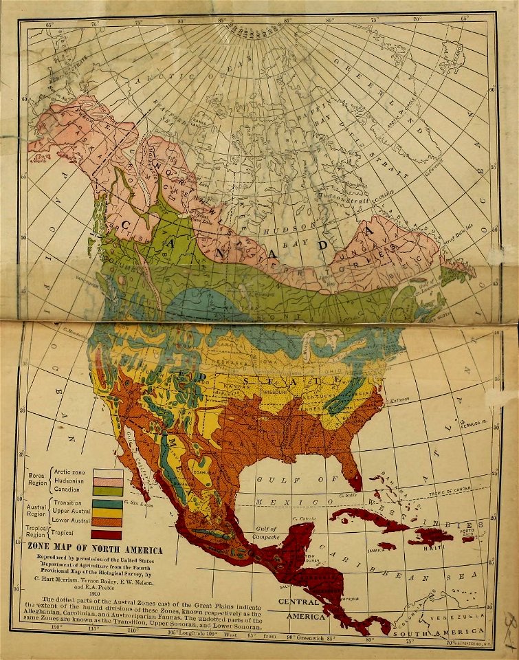
the geographical distribution of animals (book)
nearctic
a map of the british empire in america with the french and spanish settlements adjacent thereto
1730s maps of the caribbean
a map of the british empire in america with the french and spanish settlements adjacent thereto
1730s maps of central america
insects
maps
lawrence h. slaughter collection of english maps, charts, globes, books and atlases
nypl lionel pincus and princess firyal map division
lawrence h. slaughter collection of english maps, charts, globes, books and atlases
covens en mortier
a map of the british empire in america with the french and spanish settlements adjacent thereto
1730s maps of the caribbean
a map of the british empire in america with the french and spanish settlements adjacent thereto
1730s maps of the caribbean
paulownia tomentosa (cultivated in north america)
nrcs new york (state) distribution maps
maps of the yucatan peninsula
1801 maps of north america
maps in the library of congress
old maps of barbados
considérations géographiques et physiques sur les nouvelles découvertes au nord de la grande mer
1750s maps of the russian empire
lawrence h. slaughter collection of english maps, charts, globes, books and atlases
1700s maps of north america
lawrence h. slaughter collection of english maps, charts, globes, books and atlases
nypl lionel pincus and princess firyal map division
101 - 200 of 451
Next page
/ 5


![North America: based on the observations of Mrs. de l'Académie Royale des Sciences & some others, & on the most recent memoirs, 1700 [i.e. 1708]](https://cdn.creazilla.com/illustrations/10001447935/north-america-based-on-the-observations-of-mrs-de-lacadmie-royale-des-sciences-some-others-on-the-most-recent-memoirs-1700-ie-1708-sm.webp)